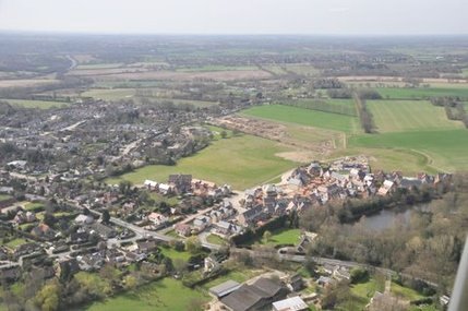
Great Horkesley village
Located in north-east Essex, the parish of Great Horkesley stretches between Colchester's northern bypass (the A12) and the River Stour, which forms the county boundary with Suffolk. The principal settlement on Horkesley Heath lies 3 miles or so north of Colchester city centre. The northern end of the parish lies within the Dedham Vale Area of Outstanding Natural Beauty, known as Constable Country.
The name Horkesley, first recorded c. 1130, combines 'ley', a woodland clearing, with a word meaning either dirty or a temporary shelter. The former would be consistent with the originally boggy nature of the pasture across which the Romans had constructed the Colchester to Sudbury road now known as "The Causeway" and designated A134. Visitors beware: confusingly, to both the north and the south of The Causeway, the A134 is named Nayland Road!
In recent years Colchester Council has designated most the land south of the A12 for residential development. While this has brought closer to the village a new secondary school, shops, employment and recreational facilities, it has heightened concerns that Great Horkesley will be swallowed up as urban Colchester continues to grow. The parish council is determined to resist this and to maintain the semi-rural character of the village.
The village has good bus links into Colchester; service intervals vary throughout the day and evening. All buses pass Colchester (North) Station which 2¼ miles away. Click to find more bus service information .
Click here for a map of the Parish Boundaries. A extensive history of the parish can be found in British History Online.